Sign In
Upcoming Event
 Free Newsletter

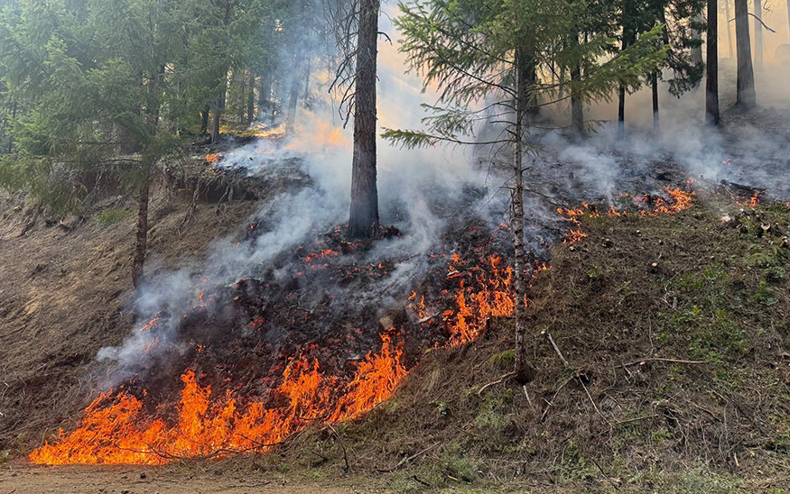
The Castle Fire is burning on Umpqua National Forest in challenging terrain. (PHOTO: VIA REUTERS CONNECT)
Oregon wildfires burn 1.5M acres destroying homes, closing highways
reuters//July 29, 2026//


More than 1.5 million acres of active wildfire is burning across Oregon in 34 major blazes that are taking an increasing toll on the state. Smoke from the fires in eastern Oregon and in southwest Idaho are causing unhealthy air quality alerts throughout Idaho.
At a Glance:
- Oregon wildfires burn more than 1.3 million acres
- Interstate 84 closed between Baker City and Ontario
- Evacuation orders issued for Big Grass Fire near Oregon-Idaho border
The Bench and Beachcomb fires in Oregon, which exploded over the weekend near Warm Springs and Madras, combined to grow to 40,000 acres and have burned six homes. That brings the total number of homes lost in the fires this year to 20 ― a number likely to increase.
Meanwhile, new fires in eastern Oregon have roared to megafire status rapidly, including the nearly 200,000-acre Big Grass Fire and the 131,000-acre Coleman Creek Fire.
Western Oregon has seen far fewer wildfires ― although not entirely ― and friendly west winds have continued to push smoke east of the Cascades.
All totaled, there are 12,500 fire personnel working blazes across the state.
Here’s a roundup of the many fires burning across the state, moving generally west to east.
Highway closures span the state, including Interstate 84
A number of major highways are closed or partly closed across central and eastern Oregon on July 27 due to wildfires. They include:
- A roughly 80-mile stretch of Interstate 84 between Baker City and Ontario has one lane open as of 3 p.m. on July 27.
- S. Highway 20 between Burns and Ontario is closed.
- S. Highway 26 east of Prineville.
- Oregon Highway 245 south of Baker City.
- S. Highway 30 south of The Dalles.
Air quality advisory issued for central, eastern Oregon, 30 Idaho counties
An air quality advisory has been issued for numerous counties in central and eastern Oregon and into Idaho.
The Oregon counties impacted include: Baker, Crook, Gilliam, Grant, Harney, Jefferson, Malheur, Morrow, Umatilla, Union, Wallowa, Wasco and Wheeler counties.
In Idaho, 30 counties are under air quality alerts due to fires. Ada, Adams, Bannock, Bingham, Blaine, Boise, Butte, Camas, Canyon, Cassia, Clearwater, Custer, Elmore, Gem, Gooding, Idaho, Jerome, Latah, Lemhi, Lewis, Lincoln, Minidoka, Nez Perce, Owyhee, Payette, Power, Twin Falls, Valley and Washington counties all had burn bans in effect because of poor air quality, according to the Idaho Department of Environmental Quality.
Oregon already closing in on record for acres burned
Oregon is closing in on its record for acres burned in a single season ― and it’s not even August.
So far, wildfires have blackened 1.47 million acres. That’s not far off the 1.97 million acres burned recorded in 2024. The most destructive wildfire season by far remains the 2020 Labor Day Fires season.
Evacuation orders remain for Big Grass Fire
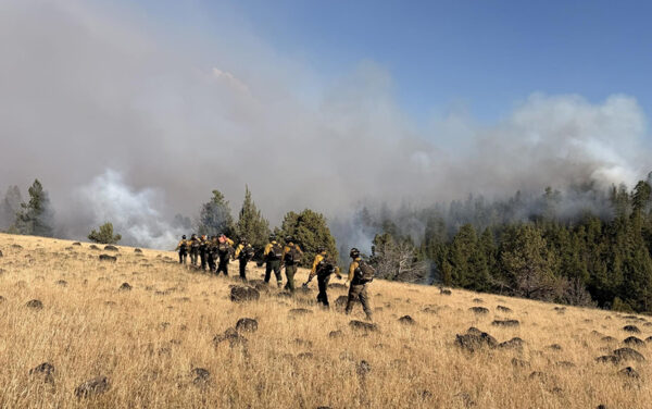
Evacuation orders remained in place for the 196,962-acre Big Grass Fire burning near the eastern Oregon-Idaho state line. As of July 27, the fire was 5% contained.
A Level 3 evacuation order was issued for Pleasant Valley, South Mountain and Jordan Valley areas by the Owyhee County Sheriff’s Office on July 25. A Level 1 evacuation order was issued for Triangle from Pleasant Valley Road, including Triangle Reservoir and Flint Creek Road area, on July 26.
The sheriff’s office asked residents to use Bachman-Grade Road through Oreana in case of further evacuation notices.
Fox Fire near Huntington closed areas of Interstate 84 eastbound
Interstate 84 eastbound was closed at Exit 304 on July 27 due to the uncontained Fox Fire near Huntington. The fire was 46,070 acres, according to a morning update.
Level 2 and 3 evacuation orders for areas of Baker County remained near Morgan Mountain and Brownlee Reservoir, searchable on the Genasys system online.
Castle Fire grows to 1,400 acres in Rogue-Umpqua Divide area
The lightning-ignited Castle Fire was mapped at 1,400 acres in Umpqua National Forest between Roseburg and Crater Lake, in the area near the Rogue-Umpqua Divide Wilderness area.
A type 3 incident management team is handling the blaze. Popular South Umpqua Falls Campground and Day Use Area was closed as of July 27. There is a wider closure around the area as well.
Full evacuation maps can be found using the RAPTOR mapping system.
Grasshopper Fire reaches 10,000 acres near Mount Hood
The Grasshopper Fire burning east of Mount Hood was mapped at 10,000 acres largely in the Badger Creek Wilderness.
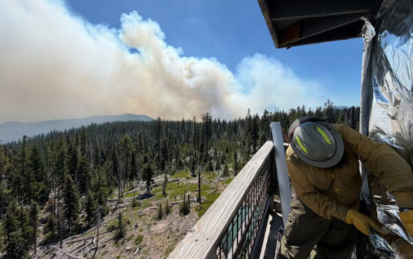
Level 1, 2 and 3 evacuations were in place for the forest and Tygh Valley west of Maupin. The popular Flag Mountain Lookout site was wrapped in fire-resistant material by crews over the weekend.
Full evacuation maps can be found using the RAPTOR mapping system.
Bench/Beachcomb Fires combine into 40,000 acre blaze
The Bench and Beachcomb Fires, which started last week likely during the lightning storm, merged and grew to 40,000 acres 4 miles southwest of Warm Springs. The fire is now known simply as the Bench Fire, according to the Confederated Tribes of Warm Springs Fire Management.
The fires shut down Highway 26 over the weekend but the main highway from Mount Hood to Madras is now open.
Much of Warm Springs remains under a level 3 “go now” evacuation in addition to Pelton Park, Pelton Dam, Dry Hollow and Lake Simtustus. Full evacuation maps can be found using the RAPTOR mapping system.
However, the popular Kah-Nee-Ta Hot Springs Resort is not under any evacuation orders and is fully open in a fire-safe zone, fire crews noted.
The evacuation levels have nearly merged with the nearby Akawa Butte, 10 Mile and Brewer fires, which all surround Madras.
Crews expand mop-up operations on Akawa Butte Fire near Sisters
Fire activity decreased on the Akawa Butte Fire burning around five miles northeast of Sisters on July 26. Crews expanded mop-up operations around the fire’s perimeter.
“Crews will continue holding and strengthening lines along active areas and structures and mopping up through the night,” an evening report said.
The fire grew to 27,307 acres at 5% containment. Warm and dry conditions are expected to continue into this week without the high winds seen through the weekend.
Popular trails and recreation sites near Sisters were closed including: Black Butte Trail, Lower Black Butte Trailhead, Monty Campground, Perry South Campground, Indian Ford Campground, Green Ridge Lookout.
Levels 1, 2, and 3 evacuation orders remain in effect. Some areas around Indian Ford Road, Old Wagon Road, West Meadow Parkway, and Tumbleweed Turn were downgraded to a Level 2 evacuation order.
Fires merge in the 200,000 acre Rowe Creek Fire Complex, Fossil Bed closures remain
The Crosswhite, Brewer and Green Mountain Fires merged into one larger fire area on July 27 as crews continue to fight the Rowe Creek Fire Complex burning around 10 miles south of Fossil.
“Oregon State Fire Marshal structural task forces will continue structure protection and support firing operations in threatened areas,” a morning report said.
The complex was at 209,546 acres and 35% contained on July 27. This change in overall acreage cannot be confirmed yet because an infrared flight has not mapped the full perimeter, officials said.
The Clarno and Painted Hills units of the Painted Hills Unit of John Day Fossil Beds National Monument remain closed. Level 1, 2, and 3 evacuation orders remain in place for areas in Wheeler and Wasco counties.
BLM-managed lands along both sides of the John Day River from Service Creek to the Columbia River remain closed.
New fire grows rapidly in Hay Creek Fire Complex near Antelope; Washington Family Ranch evacuated
Crews contained three of the five fires in the Hay Creek Fire Complex burning 10 miles north of Condon. However, a rapidly spreading fire prompted new evacuations, including at Washington Family Ranch.
“Strong winds during yesterday’s Red Flag Warning drove significant growth on the Little Buck Fire, the newest and most active fire in the Hay Creek Complex, pushing it south over Oregon Highway 218,” a report said on July 26.
The complex grew to 181,821 acres at 60% containment, according to the National Interagency Fire Center on July 26.
Level 1 and 2 evacuation notices remain in place for areas south of Interstate 84 to Mayville, and level 3 evacuation notices are in place for areas around Antelope.
Crews work to strengthen firelines on the Coyote and Henry fires burning 15 miles southeast of Prineville
High winds challenged firefighters on the Coyote and Henry fires, located about 15 miles southeast of the Prineville Reservoir State Park.
The 17,446-acre Coyote Fire was at 57% containment, and the 28,827-acre Henry Fire was at 35% containment on July 27.
For the Coyote Fire, crews continued to build and strengthen containment lines. Air crews will remain vigilant for new starts.
Level 3 evacuation levels were in place around Maupin Butte as well as near Drake and Coyote Butte. All National Forest System lands, roads and trails within the Maury Mountains remain closed.
Shingle Fire sees rapid growth near Mitchell, crews protect structures
The Shingle Fire burning around 13 miles southeast of Mitchell saw rapid growth over the weekend as challenging weather pushed the fire toward Highway 26 on July 26.
“An estimated 170 homes remain threatened as firefighters continue working to protect lives and property,” an evening report said on July 26.
The Shingle Fire grew to 60,777 acres and was uncontained, according to the National Interagency Fire Center on July 27.
Level 2 and 3 evacuation orders were in place for areas around Table Mountain. Areas around the John Day Fossil Beds National Monument were under Level 1 and 2 evacuation orders.
Second Flat Fire northeast of Highway 20
Level 1, 2 and 3 evacuations orders were in place for multiple areas of Harney County on July 27 for the 85,379-acre Second Flat Fire, burning 6 miles northeast of Highway 20.
The fire was 5% contained on July 27. Evacuation zones are searchable on the Genasys system online.
Hagan Fire near Tollgate merged with Ninemile Fire
The Hagen Fire located about nine miles southwest of Tollgate merged with the Ninemile Fire on July 26. On July 27, the fire remained uncontained at 24,038 acres.
Firefighters maintained containment south of Bingham Road as the fire primarily grew to the south and east.
Level 3, 2 and 1 evacuation orders remained for multiple areas of Umatilla County, searchable on the Genasys system online.
Crews increase containment on Jackass Butte Fire near Harney Lake
Crews increased containment on the Jackass Butte Fire off Jackson Mountain Road to 30% on July 27.
The fire was at 18,539 acres on July 27 with no evacuation orders in place.
Hat Fire near Hat Butte 35% contained
The Hat Fire near Hat Butte was 35% contained on July 26 and at 41,728 acres.
No evacuation orders were in place.
Bald Mountain Fire spurs evacuation orders in areas of Harney County
Evacuation orders remained in areas of Harney County for the 32,137-acre Bald Mountain Fire, at 1% containment on July 27.
Crews worked to secure the southern edge containment line and protect Riddle Road and Manns Lake Ranch on July 26.
Level 3 and 1 evacuation zones are searchable on the Genasys system online.
Coleman Creek Fire uncontained near Warm Springs Reservoir and Black Butte
The 131,377-acre Coleman Creek Fire was active during the day and overnight on July 26, expanding north and east, toward Highway 20 East, Riverside and Juntura.
Crews worked to keep the fire south of Highway 20 East and to secure the area near Riverside.
Level 3 and 2 evacuation orders remained for areas of Harney County, including Black Butte, searchable on the Genasys system online.
Burnt Creek Fire uncontained near Enterprise
Crews work to keep the Burnt Creek Fire burning 33 miles north of Enterprise from advancing north on July 27.
A team developed a plan to protect homes and infrastructure along Jospeh Canyon Road and around Sled Springs on July 26.
The fire was at 3,076 acres with no containment on July 27.
A Level 1 evacuation order remained for all residents on Joseph Creek Road.
This article originally appeared on Salem Statesman Journal: Oregon wildfires burn 1.3M acres destroying homes, closing highways
Reporting by Zach Urness, Riley Ellis and Makenzie Stamets, Salem Statesman Journal. Story distributed through USA TODAY Network via Reuters Connect.





 Loading ...